Using request parameters to limit query results
Source:vignettes/articles/request-params.Rmd
request-params.RmdRequesting a full layer with emodnet_get_layers() will
return the geometries for all features in that layer, potentially a
large amount of data.
Some basic ability to limit the output of any query is possible by
providing additional parameters to the feature request query. This can
be achieved by passing additional arguments to
emodnet_get_layers(...).
For details on all available parameters consult the GetFeature
Geoserver documentation. Also note that there are differences
in available parameters between different version of WFS
specifications. We recommend and mainly document using the default
and latest version ("2.0.0") which is supported by all
EMODnet WFS services.
Initialise a WFS client
Let’s start by loading emodnet.wfs and initialising a WFS client to
the human_activities WFS service.
library(emodnet.wfs)

wfs <- emodnet_init_wfs_client("human_activities")
#> ✔ WFS client created successfully
#> ℹ Service: "https://ows.emodnet-humanactivities.eu/wfs"
#> ℹ Version: "2.0.0"
Return single feature using feature ID
We can restrict the query to a single feature using
featureID and providing the ID of a specific feature.
emodnet_get_layers(
  wfs = wfs,
  layers = "pipelines",
  featureID = "pipelines.1",
  simplify = TRUE
)
#> Simple feature collection with 1 feature and 13 fields
#> Geometry type: MULTILINESTRING
#> Dimension:     XY
#> Bounding box:  xmin: -5.87186 ymin: 35.99551 xmax: -5.836784 ymax: 36.12588
#> Geodetic CRS:  WGS 84
#>        gml_id   id status medium operator size_in length_m year from_loc to_loc country_co
#> 1 pipelines.1 <NA> Active   <NA>     <NA>    <NA> 15467.17 <NA>     <NA>   <NA>         ES
#>   country notes                       the_geom
#> 1   Spain  <NA> MULTILINESTRING ((-5.87186 ...
Return specific number of features
If the ID of the feature is unknown but we still want to limit the
number of features returned, we use the count parameter for
WFS 2.0.0 or the maxFeatures parameter for earlier WFS
versions to restrict the number of features returned. In this example we
restrict the query to the first feature.
emodnet_get_layers(
  wfs = wfs,
  layers = "pipelines",
  count = 1L,
  simplify = TRUE
)
#> Simple feature collection with 1 feature and 13 fields
#> Geometry type: MULTILINESTRING
#> Dimension:     XY
#> Bounding box:  xmin: 24.98448 ymin: 60.19078 xmax: 25.01292 ymax: 60.19293
#> Geodetic CRS:  WGS 84
#>           gml_id   id status medium operator size_in length_m year from_loc to_loc
#> 1 pipelines.3463 <NA>    n/a   <NA>     <NA>    <NA>  1628.03 <NA>     <NA>   <NA>
#>   country_co country                    notes                       the_geom
#> 1         FI Finland Finnish Transport Agency MULTILINESTRING ((25.01292 ...
Order features
Exactly which features will be returned depends in the internal
structure of the data. However, we can sort the returned selection based
on an attribute value using the sortBy parameter.
Say we wanted to return 5 of the longest marine pipelines. In the
following example, we sort by the "length_m" attribute and
combine it with the count parameter to restrict the number
of features returned. This returns the first 5 features after the data
has been ordered by "length_m". Some pipelines do not have
their lengths recorded, we will skip them with a CQL Filter.
emodnet_get_layers(
  wfs = wfs,
  layers = "pipelines",
  sortBy = "length_m+D",
  count = 5L,
  simplify = TRUE,
  cql_filter = "length_m IS NOT NULL"
)
#> Simple feature collection with 5 features and 13 fields
#> Geometry type: MULTILINESTRING
#> Dimension:     XY
#> Bounding box:  xmin: 2.249597 ymin: 51.04064 xmax: 28.14228 ymax: 60.52758
#> Geodetic CRS:  WGS 84
#>           gml_id        id  status medium         operator size_in  length_m year
#> 1 pipelines.3423      <NA>  Active    Gas   Nord Stream AG      48 2443360.2 2011
#> 2 pipelines.3424      <NA> Planned    Gas Nord Stream 2 AG      48 1210867.9 2021
#> 3   pipelines.52 PL0187_PR  Active    Gas      Statoil ASA      42  836155.4 <NA>
#> 4  pipelines.517    326374  Active    Gas        GASSCO AS      42  832197.9 <NA>
#> 5   pipelines.53 PL0186_PR  Active    Gas      Statoil ASA      40  807749.5 <NA>
#>        from_loc         to_loc country_co         country           notes
#> 1    Vyborg, RU     Lubmin, GE     DE, RU Germany, Russia Schematic Route
#> 2 Kurgalsky, RU     Lubmin, GE     DE, RU Germany, Russia Schematic Route
#> 3  Draupner (N) Duinkerken (F)         NL     Netherlands            <NA>
#> 4    DRAUPNER E      DUNKERQUE         NO          Norway            <NA>
#> 5  Sleipner (N)  Zeebrugge (B)         NL     Netherlands            <NA>
#>                         the_geom
#> 1 MULTILINESTRING ((18.00045 ...
#> 2 MULTILINESTRING ((28.14228 ...
#> 3 MULTILINESTRING ((2.249597 ...
#> 4 MULTILINESTRING ((2.458616 ...
#> 5 MULTILINESTRING ((3.298373 ...
The default sort operation is to sort in ascending order. Some WFS
servers require the sort order to be specified. In this case, append a
+A to the attribute character string passed to
sortBy. Conversely, here we add a +D to sort
in descending order.
Return blocks of features from specific starting point
Finally in WFS version 2.0.0 (and also available in earlier versions
on GeoServer) a startIndex parameter was introduced,
allowing users to specify the starting index of features to be
returned.
#> [1] 3951For example, the full "pipelines" layer contains 3951
features.
n_features <- layer_attributes_tbl(wfs = wfs, layer = "pipelines") %>% nrow()

n_features
Setting the startIndex to n_features - 4
(3947) returns the last 4 features.
startIndex <- n_features - 4L
startIndex
#> [1] 3947

emodnet_get_layers(
  wfs = wfs,
  layers = "pipelines",
  startIndex = startIndex,
  simplify = TRUE
)
#> Simple feature collection with 4 features and 13 fields
#> Geometry type: MULTILINESTRING
#> Dimension:     XY
#> Bounding box:  xmin: 3.990801 ymin: 53.53329 xmax: 14.4857 ymax: 55.81712
#> Geodetic CRS:  WGS 84
#>           gml_id     id     status medium operator size_in length_m year from_loc to_loc
#> 1 pipelines.3948 154802 Not in use    Gas     <NA>    <NA>       NA <NA>     <NA>   <NA>
#> 2 pipelines.3949 154812 Not in use    Gas     <NA>    <NA>       NA <NA>     <NA>   <NA>
#> 3 pipelines.3950 154982     Active    Gas     <NA>    <NA>       NA <NA>     <NA>   <NA>
#> 4 pipelines.3951 155942     Active    Gas     <NA>    <NA>       NA <NA>     <NA>   <NA>
#>   country_co country notes                       the_geom
#> 1         DE Germany  <NA> MULTILINESTRING ((14.48506 ...
#> 2         DE Germany  <NA> MULTILINESTRING ((14.4857 5...
#> 3         DE Germany  <NA> MULTILINESTRING ((4.058202 ...
#> 4         DE Germany  <NA> MULTILINESTRING ((4.019116 ...
We can also combine startIndex and count to
return specific blocks of features. For example, in the following query
we request features 5-9 by supplying a startIndex of 4 and
count of 5.
Note that startIndex uses 0 as a starting
index (0 indicates the first feature), hence we set it to 4
in order to start at the 5th feature.
emodnet_get_layers(
  wfs = wfs,
  layers = "pipelines",
  startIndex = 4L,
  count = 6L,
  simplify = TRUE
)
#> Simple feature collection with 6 features and 13 fields
#> Geometry type: MULTILINESTRING
#> Dimension:     XY
#> Bounding box:  xmin: -8.336029 ymin: 51.19448 xmax: -7.947595 ymax: 51.8236
#> Geodetic CRS:  WGS 84
#>         gml_id     id status medium operator size_in  length_m year    from_loc to_loc
#> 1  pipelines.5 F43__3    n/a   <NA>     <NA>    <NA> 10038.745 <NA>     Kinsale   <NA>
#> 2  pipelines.6 F43__4    n/a   <NA>     <NA>    <NA> 20011.185 <NA> Ballycotton   <NA>
#> 3  pipelines.7 F43__5    n/a   <NA>     <NA>    <NA> 10853.853 <NA>     Kinsale   <NA>
#> 4  pipelines.8 F43__6    n/a   <NA>     <NA>    <NA>  5397.224 <NA>     Kinsale   <NA>
#> 5  pipelines.9 F43__7    n/a   <NA>     <NA>    <NA> 73853.753 <NA>     Kinsale   <NA>
#> 6 pipelines.10 F43__8    n/a   <NA>     <NA>    <NA> 56242.374 <NA> Seven Heads   <NA>
#>   country_co country notes                       the_geom
#> 1         IE Ireland  <NA> MULTILINESTRING ((-8.186204...
#> 2         IE Ireland  <NA> MULTILINESTRING ((-8.017066...
#> 3         IE Ireland  <NA> MULTILINESTRING ((-8.017356...
#> 4         IE Ireland  <NA> MULTILINESTRING ((-8.179044...
#> 5         IE Ireland  <NA> MULTILINESTRING ((-7.947595...
#> 6         IE Ireland  <NA> MULTILINESTRING ((-8.217298...
This in combination with, for example, a for loop, can
be used to download and process large layer which might not be able to
be handled in R in smaller, more manageable blocks of features.
Return data for specific attributes
Finally, we can specify specific attributes for which we want data
returned using parameter propertyName.
To limit data returned to the single attribute "country"
from just 3 features, we use parameters
propertyName = "country" and count = 3.
Note that when limiting data to specific attributes, all other
columns are returned as NA (including any spatial, in this
case the_geom, column).
emodnet_get_layers(
  wfs = wfs,
  layers = "pipelines",
  propertyName = "country",
  count = 3L,
  simplify = TRUE
)
#> Simple feature collection with 3 features and 13 fields (with 3 geometries empty)
#> Geometry type: GEOMETRYCOLLECTION
#> Dimension:     XY
#> Bounding box:  xmin: NA ymin: NA xmax: NA ymax: NA
#> Geodetic CRS:  WGS 84
#>           gml_id   id status medium operator size_in length_m year from_loc to_loc
#> 1 pipelines.3463 <NA>   <NA>   <NA>     <NA>    <NA>       NA <NA>     <NA>   <NA>
#> 2 pipelines.3702 <NA>   <NA>   <NA>     <NA>    <NA>       NA <NA>     <NA>   <NA>
#> 3 pipelines.3707 <NA>   <NA>   <NA>     <NA>    <NA>       NA <NA>     <NA>   <NA>
#>   country_co country notes                 the_geom
#> 1       <NA> Finland  <NA> GEOMETRYCOLLECTION EMPTY
#> 2       <NA> Finland  <NA> GEOMETRYCOLLECTION EMPTY
#> 3       <NA> Finland  <NA> GEOMETRYCOLLECTION EMPTY
To limit to multiple attributes, separate each attribute name in the
character string supplied to propertyName by a comma.
emodnet_get_layers(
  wfs = wfs,
  layers = "pipelines",
  propertyName = "country,the_geom",
  count = 3L,
  simplify = TRUE
)
#> Simple feature collection with 3 features and 13 fields
#> Geometry type: MULTILINESTRING
#> Dimension:     XY
#> Bounding box:  xmin: 24.90736 ymin: 60.1819 xmax: 27.11348 ymax: 60.5359
#> Geodetic CRS:  WGS 84
#>           gml_id   id status medium operator size_in length_m year from_loc to_loc
#> 1 pipelines.3463 <NA>   <NA>   <NA>     <NA>    <NA>       NA <NA>     <NA>   <NA>
#> 2 pipelines.3702 <NA>   <NA>   <NA>     <NA>    <NA>       NA <NA>     <NA>   <NA>
#> 3 pipelines.3707 <NA>   <NA>   <NA>     <NA>    <NA>       NA <NA>     <NA>   <NA>
#>   country_co country notes                       the_geom
#> 1       <NA> Finland  <NA> MULTILINESTRING ((25.01292 ...
#> 2       <NA> Finland  <NA> MULTILINESTRING ((27.11348 ...
#> 3       <NA> Finland  <NA> MULTILINESTRING ((24.90967 ...
Limit spatial extent using a boundary box
The bbox parameter allows us to search for features that
are contained (or partially contained) inside a box of user-defined
coordinates. The format of the bbox parameter in most
EMODnet WFS cases (assuming you are using version 2.0.0) is
bbox=a1,b1,a2,b2,[crs] where a1,
b1, a2, and b2 represent the
coordinate values. The optional crs parameter is used to
name the coordinate reference system (CRS) for the bbox coordinates (if
they are different to the featureTypes native CRS.) The order of
coordinates passed to the bbox parameter depends on the
coordinate system used (this is why the coordinate syntax isn’t
represented with x or y).
In the following example, we specify the bounding box by proving
coordinates in the order xmin,ymin,xmax,ymax and specifying
that coordinates are given in the EPSG:4326 coordinate
reference system.
bbox_response <- emodnet_get_layers(
  service = "biology",
  layers = "mediseh_posidonia_nodata",
  bbox = "22.9,34.4,26.8,35.8,EPSG:4326",
  simplify = TRUE
)
#> ✔ WFS client created successfully
#> ℹ Service: "https://geo.vliz.be/geoserver/Emodnetbio/wfs"
#> ℹ Version: "2.0.0"

bbox_response %>%
  sf::st_cast(to = "MULTILINESTRING") %>%
  mapview::mapview(burst = TRUE, legend = FALSE)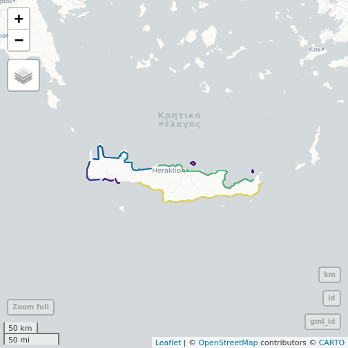
Non-standard Vendor Parameters
WFS vendor parameters are additional, non-standard request parameters defined by an implementation to provide enhanced capabilities.
The majority of EMODnet services are GeoServer WFS implementations which support a variety of vendor-specific WFS parameters.
One of these are cql_filters. These are
handled explicitly through the emodnet.wfs package through the
cql_filter argument in emodnet_get_layers()
and are documented in detail in
article("ecql_filtering").
For additional vendor parameters available through GeoServer implementations please refer to the WFS vendor parameters documentatio
Exceptions are the Chemistry (Eutrophication by sea region, Eutrophication) services which uses Python and Chemistry (Litter) which uses MapServer so vendor parameters for these services might differ.